
With its towering rocky spires, Blodgett Canyon is a geological highlight of the Bitterroot Mountains for summer visitors. In winter, however, it becomes a frozen wonderland.
And while it’s quite popular in warmer months, it seems hardly anyone goes there in the snow. On New Year’s Day, for example, we saw four other people, and passed only two of them on the trail.
When we arrived at the trailhead in the Bitterroot National Forest northwest of Hamilton, the temperature on the dashboard of our SUV read 1 degree. And while the sky was blue and the north rim of the canyon sunny, the south rim kept the creek bottom shaded.
In the first couple of miles, the trail parallels the creek upstream to the west, mostly through the trees above but also along its edge in a few spots.
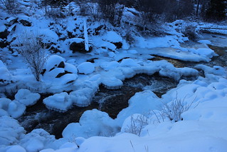
Off the side of the trail, hoarfrost clung to the branches of shrubs. At a frozen bend in the creek, bigger crystals dotted the ice. At another bend farther up the trail, I was able to get an closer view of the intricate ice “flowers.”
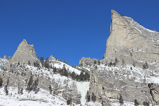
At 2 miles, the trail leaves the trees and rounds a boulder-filled bend. Here we could see across the canyon to a couple of ice climbers on a frozen cascade between Nez Perce and Shoshone spires on the north rim.
A short distance up the trail, we strapped on snowshoes and continued through the powder. Where it returns to the side of the cascading creek, we found icy pools – including one with a small frozen circle stuck in an eddy.
At about 3 miles, the trail crosses a bridge to the north bank of the creek, the canyon widens and a natural rock arch is visible on the south rim. A little more than a quarter mile farther, where the trail passes between a boulder field and a wide section of the creek, we stopped when the deep snow started to give the dogs trouble.
On the way back down the canyon, with the shade rising up the north rim, we passed the only two people we would see on the trail all day.
Here are more photos of Blodgett Canyon.
Distance: About 6.5 miles round trip.
Trailhead: North of Hamilton, turn west off U.S. Highway 93 onto Bowman Road and drive three-quarters of a mile. Turn south on Ricketts Road and continue 2 miles. After Ricketts turns west, continue onto Blodgett Camp Road and follow it west, north and west again about 3.9 miles to the trailhead.
